|
||||||||||||||||||||
| 310-613-5473 | ||||||||||||||||||||
|
|||||||||||||||||||||||||||||||||||||||||||||||||||||||||||||||||||||||
|
To register for the next guided Death Valley Expedition click here |
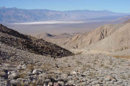
 Looking southwest over Death Valley
|
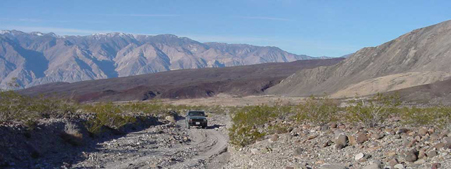
 This is a 4 day trip covering the north and west end of Death Valley, Saline Valley and Eureka Valley.
(Saline Valley and Eureka Valley are also part of the Death Valley National Park). We will start near Ridgecrest, California.
The plan is to camp each night. Death Valley is quite remote
with long distances (and drive time) between destinations. We will spend a lot of time driving on the back roads and camping
just to explore where they go and to say we did it. We don't stop as a rule at places that are paved and you can reach by passenger car.
There is very limited cell phone coverage. There are opportunities to buy expensive
gas.
Just don't rely on a gas station to be there when you need gas - bring extra. We will avoid the paved road as much as possible.
Expect plenty of washboard roads (and we mean extreme washboard that will shake every part of your vehicle, gear and shocks).
This is not the trip for you if you abhor washboard,
dust and scenic beauty. Death Valley abounds in history, mines, ghost towns, and
natural wonders - like moving rocks. It will not be possible to see it all even thought it will seem like it.
At least one night, we will camp next to the warm springs. Bring a swim suit so you can enjoy the pool. However, it is
clothing optional so make your own decision!
This is a 4 day trip covering the north and west end of Death Valley, Saline Valley and Eureka Valley.
(Saline Valley and Eureka Valley are also part of the Death Valley National Park). We will start near Ridgecrest, California.
The plan is to camp each night. Death Valley is quite remote
with long distances (and drive time) between destinations. We will spend a lot of time driving on the back roads and camping
just to explore where they go and to say we did it. We don't stop as a rule at places that are paved and you can reach by passenger car.
There is very limited cell phone coverage. There are opportunities to buy expensive
gas.
Just don't rely on a gas station to be there when you need gas - bring extra. We will avoid the paved road as much as possible.
Expect plenty of washboard roads (and we mean extreme washboard that will shake every part of your vehicle, gear and shocks).
This is not the trip for you if you abhor washboard,
dust and scenic beauty. Death Valley abounds in history, mines, ghost towns, and
natural wonders - like moving rocks. It will not be possible to see it all even thought it will seem like it.
At least one night, we will camp next to the warm springs. Bring a swim suit so you can enjoy the pool. However, it is
clothing optional so make your own decision!
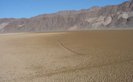 "The Racetrack is a unique attraction of Death Valley National Park that not many park visitors get to see.
It's a dry lakebed in a very remote and beautiful area.
On the north end of the lakebed is a rock formation known as the grandstands.
Rocks from the grandstands and other nearby formations break off and fall onto the lake.
There, they perform feats that make this remote playa world-famous.
They move! But after all these years, a hundred or more since this phenomenon was brought to the attention of naturalists
studying Death Valley, no one has ever seen them move. These rocks aren't boulders; most are perhaps a foot or so tall,
but can still weigh a lot and are not easy to lift.
The evidence that they move is the trails they leave behind them as they scoot around the lake.
You'll find a rock sitting innocently anywhere on the playa -- from next to the grandstand to the far southern edge --
and behind it will be a trail, from the rock sliding across the fine clay surface of the lakebed."
(The Sliding Rocks on the Racetrack Playa by Len Wilcox www.desertusa.com)
"The Racetrack is a unique attraction of Death Valley National Park that not many park visitors get to see.
It's a dry lakebed in a very remote and beautiful area.
On the north end of the lakebed is a rock formation known as the grandstands.
Rocks from the grandstands and other nearby formations break off and fall onto the lake.
There, they perform feats that make this remote playa world-famous.
They move! But after all these years, a hundred or more since this phenomenon was brought to the attention of naturalists
studying Death Valley, no one has ever seen them move. These rocks aren't boulders; most are perhaps a foot or so tall,
but can still weigh a lot and are not easy to lift.
The evidence that they move is the trails they leave behind them as they scoot around the lake.
You'll find a rock sitting innocently anywhere on the playa -- from next to the grandstand to the far southern edge --
and behind it will be a trail, from the rock sliding across the fine clay surface of the lakebed."
(The Sliding Rocks on the Racetrack Playa by Len Wilcox www.desertusa.com)
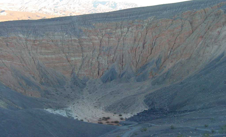 "At the northern end of the Cottonwood Mountains, lies a field of volcanic craters, the largest of which the Indians named
Ubehebe, which means big basket in the rock. Ubehebe was formed around 6000 years ago when underground water came in
contact with molten rock. The resultant steam pressure caused a massive explosion, sending debris high into the sky,
blanketing the area with jagged rock up to 20ft in depth. There are several craters in the area, the most easily accessed
being the largest, Ubehebe. Walking around the rim is very easy though winds are quite often extreme in this part of
Death Valley. A simple 500ft descent awaits those who feel like walking to the bottom of Ubehebe;
a rather more strenuous ascent awaits those who want to climb out, as the slopes are lined with a loose volcanic rubble
that offers little purchase." (from USGS web site Death Valley Field Trip)
"At the northern end of the Cottonwood Mountains, lies a field of volcanic craters, the largest of which the Indians named
Ubehebe, which means big basket in the rock. Ubehebe was formed around 6000 years ago when underground water came in
contact with molten rock. The resultant steam pressure caused a massive explosion, sending debris high into the sky,
blanketing the area with jagged rock up to 20ft in depth. There are several craters in the area, the most easily accessed
being the largest, Ubehebe. Walking around the rim is very easy though winds are quite often extreme in this part of
Death Valley. A simple 500ft descent awaits those who feel like walking to the bottom of Ubehebe;
a rather more strenuous ascent awaits those who want to climb out, as the slopes are lined with a loose volcanic rubble
that offers little purchase." (from USGS web site Death Valley Field Trip)