|
||||||||||||||||||||
| 310-613-5473 | ||||||||||||||||||||
|
|||||||||||||||||||||||||||||||||||||||||||||||||||||||||||||||||||||||
| |||||||||||||||
While many four wheelers view the trailhead as the starting point of any trip, in reality all the fun begins at the rendezvous point. That is where all drivers congregate initially. Final supplies are purchased if necessary, and trip plans are reviewed. A lot of thought should go into the selection of a meeting place. If the rendezvous spot isnt chosen properly, the trip may not get off to a good start. A good rendezvous point looks like this:
How close you can get to the trailhead varies a lot. A prime location could be 50 miles or more from the trailhead. It all depends on how remote your off-road destination isand how far away the other drivers are. Depending on the size of your group, you may need a lot of room. Select a spot that is large enough for everyone to meetincluding those with trailersbut that still has enough room for regular customers of that establishment. (Be a good sport. Dont hog the parking lot.) Big box stores always have large lots, but they arent very common in rural areas. I have used parking lots for grocery stores, restaurants and BLM field offices. Truck stops are nice, too. The parking lot for an office building might work on weekends when the business is closed. The rendezvous spot should be easy to find. This, too, can be relative. A location near a city should be more convenient than one out in the country. Also, the mapping format your guests use plays a big part. Dont assume everyone uses GPS. (And that GPS is always accurate.) Determine which kind of directions each driver is comfortable with. Some people prefer GPS coordinates. Others like a map (whether official variety or hand-drawn). Still others will ask for the address so they can type that into their GPS units. This last option has a potential downfall: In more rural settings, GPS can be less accurate. Remember that the more remote your rendezvous point is, the more likely youll need more than one type of mapping format. Be as clear as possible when you provide directions. You are probably more familiar with the area than your guests are. Dont be shy with details and directions.
In remote, rural areas you dont have a choice. Your rendezvous point is the last location that offers gas and convenience items. Your guests could be 50, 100 or more miles from home. Of course they will have to top off their tanks. Therefore, a gas station/convenience store combo is the ideal location. But heres the rub: Last-minute purchases take time. Those precious minutes come out of your day. Knowing this, it might be a good idea to arrange your rendezvous 15 to 30 minutes earlier than you originally planned. (Remember that youll have down time at the trailhead, too.) Its also important for drivers to bring along extra gas. Once off-road, you could be long distances from any gas station. Take Nevada, for example. Esmeralda and Mineral Counties are quite remote. Total surface area is some 7,400 square miles. Esmeralda has one gas station in the entire county and it is not even in the county seat which has no gas station. There are three gas stations in Mineral County, but all are in Hawthorne. Many of the rural gas stations have only 2 options for fuel: 87 octane and diesel. If you need a higher octane, bring more gas with you or add an octane booster. Gas isnt the only necessity in short supply. Cell coverage can be spotty, even nonexistent when off road. Make sure cell phones operate in and near the rendezvous point. Your guests can contact you while en route. When selecting a rendezvous point, the location might be obvious. It could be the parking lot, intersection or other noteworthy stop nearest the trailhead. In other cases, you may have a choice. Always recon those locations so youre familiar with them. Provide your guests detailed directionsin whatever format they preferand implore on all to arrive on time and ready to go. Once you leave the rendezvous point, you can focus on the trailhead and four-wheel excursion ahead.
| Related Articles from Badlands Off-road Adventures
| Did you miss the previous article?
|
Some Upcoming Events
|
We are in the process of compiling the Badlands Off-Road Adventures 2017 calendar. Our goal is to have it finalized and on the web by the end of October. If you have any requests or suggests for clinics and events for next year, we would be happy to hear them. We have two adventure trip scheduled before the end of the year: Death Valley & the T&T Railroad. The women only class is already half full. Sign up soon if you wish to attend. October marks the beginning of our class schedule in Borrego Springs. The first clinic is Oct 29th. Summary of upcoming events.
Oct 2016 Nov 2016
|
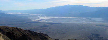
Death Valley October 21-24
This is a 4 day trip on the back roads in Death Valley. We will drive the Panamint Mountains, drive past Badwater Basin (lowest spot in North America), visit Chloride Ghost town, Titus Canyon, check out Ubehebe Crater, Teakettle junction, The Race Track & Lippencott Mine Road, camp at the Warm Springs and leave via Steal Pass up to the high meadows, then take Dedeckera Canyon down to the Eureka Sand Dunes. All four days will see some light to moderate 4-wheeling. Much of the trip is quite remote with random or no cell service. We don't plan to stop at tourist sights you can get to in a passenger car. Check out the details and sign up on the website: http://www.4x4training.com/Adventures/Deathvalley.html August 2013 Off-Road Adventures Magazine: Death Valley Excursion by Denis Snow You can register directly at http://www.4x4training.com/calendar/calendar.php#Deathvalley
|
T&T Rail Road Adventure in November
Our goal is to cross through Johnson Valley, enjoying what it has to offer, and making our way North along the old Tonopah & Tidewater (T&T) Rail Road bed to the Rasor OHV, Afton Canyon and the western edge of the Mojave Preserve. On the way we will skirt the Rodman Mountain Wilderness and cross I-40. This adventure is 2 days of scenic, historical, light wheeling and a night ( 2 if you prefer) of primitive camping under the stars. We can plan a Dutch Oven pot luck for our evening meal. Check out the details and sign up on the website: http://www.4x4training.com/Adventures/TTRailroad.html You can register directly at http://www.4x4training.com/calendar/calendar.php#TTRailroad
|
May 5, 2016 - ALL COLORS BACK in STOCK
The Orange and Red went fast last time with blue not far behind so if you want a specific color order now while we have them all available. The Bandana layout follows the Vehicle Recovery Plan with pathways to more detail. A unique section of the Bandana, gives the steps for a Winch Rigging Check: Walk through so that you verify every element of the rigging before you commit to the pull. Stuff this in your recovery kit and you will always be ready. Warning the Bandana is not a substitute for proper training and use of quality equipment used within the bounds of their safe working load. We advise you to use the information provided in the Winching Recovery Bandana at your own risk. We cannot control the quality and specifications of the equipment used and the methods actually employed. The original press release with larger graphics is on the website
|
73
| |
| Back | | Phone 310-613-5473 |