|
||||||||||||||||||||
| 310-374-8047 | ||||||||||||||||||||
|
|||||||||||||||||||||||||||||||||||||||||||||||||||||||||||||||||||||||
Veteran four-wheelers and other outdoors enthusiasts know that the weather can change in an instant. This is especially true when traveling into the mountains. You may leave your home in shorts and a t-shirt, but three hours later find yourself in need of a parka, long johns and pack boots. You cant fight the weather, but you can manage it that is, account for it through proper planning. Sadly, too many outdoors enthusiasts rely solely on the forecast from the TV station. Those dont provide the detailed information you need for your trip. Thats what well cover here. You need to dig deeper to find comprehensive and useful weather forecasts. Finding accurate weather forecasts for your destinationThe problem with most offline and online weather forecasting is that it is limited to cities and other population centers. Lets say you want to know what the forecast will be at your campsite near Needles, Calif. You havent decided whether to leave in a few days or wait a month two. Either way, youd like some forecast data. What do you do?Like many people, I start with www.weather.com (from the menu on top select Weather; and then local; enter a city) Once your citys weather comes up, you can click Weekend or 10 Day for a current trip. (I like to save the 10 Day link in my favorites file folder along with several other cities that might be representative of the weather along the route.) | ||
But what we are really after is long range intelligence using historical data. Click Monthly along the left side. The chart on the next page provides forecasted highs and lows for the current 10 days, along with historical data for the remainder of the month. Clicking on the Averages button brings up a graphic representation of the highs and lows for that area for the entire year. See Image 1. (The Averages button is on the right hand end of a little menu at the bottom of the month data. You may have to search a bit for it). In the case of Needles, we may decide to hold off our trip until fall. If you want historical averages for future months, select Daily Averages from the drop down menu just above and left of the annual chart of highs and lows, then select the month you want in the blue banner. This general information is fine, but Id like the weather forecasts for my campsite on the Old Mojave Road near Needles. I now turn to www.weather.gov. This is the National Weather Services weather forecasting service. The really cool part about this site is that it gives you Point weather forecasts; that is, the forecasts for a specific area, that take into consideration the elevation at that location. At www.weather.gov, click on the Local link under Forecasts! Here is where it gets a little challenging. The next page lists the National Weather Services offices. You need to know which one is closest to your destination. If youre not sure, scroll down (way down) to the map. For this example click on Nevada, then zoom in or out to find the nearest city (Bullhead, for this example). Click on that. | ||
Now click on another spot on the map. The forecast area moves to that spot. You could scroll the map out and move the forecast to somewhere in Death Valley and scroll back in, if you want rather than stating over with a city close to Death Valley. Heres a little trick I learned. While on the Detailed Point Forecast, look up at the address bar (all the way up in your browser). Youll see that lat and lon figures are given. If you know the coordinates for your camping area, type those in the URL. (You need to covert to decimal format, however.) Now youll see the temperature forecast for your precise destination. How cool is that? The down side to the point forecast is you can only get a 7 day forecast. You need to look at it just a few days prior to your trip. Stay in Touch with the Weather on the RoadOfficially known as NWR (for NOAA Weather Radio All Hazards), this nationwide system broadcasts Weather Service alerts, forecasts, and hazards 24 hours a day, 7 days a week.According to their website, NWR employs 1000 transmitters covering all 50 states, adjacent coastal waters, U.S. territories, and other areas. Click here for the transmitters in the state you are interested in. You might find it useful to print out the list of repeaters to take on the trip. NWR uses seven VHF channels for these broadcasts: 162.400, 162.425, 162.450, 162.475, 162.500, 162.525 and 162.550 MHz. Output power varies among the stations. That, along with terrain, affects reception. Even though NOAA has all those channels to work with, you wont find all available in a given area. In fact, a remote area may be served by only one transmitter. Program the frequencies used in your area, and let the radio pickup whichever signals it can. Gear you need for weather and temperature forecastsA radio that receives National Weather Service weather broadcasts is a must when youre going off road.FRS/GMRS and CB radios often come with one or more Weather Service frequencies built in. Ham radio operators can program their VHF rigs accordingly. Due to their external antennas, the CB & ham radios have an advantage in receiving one of the weather stations in remote areas. (Hams note: you need only memorize one frequency 162.400 - if your radio is not programed. Each of the other stations are only 25 MHz higher.) If theres a major storm coming through, a Weather Service radio will tip you off. You can find apps for this service that work on iphones, Droids, and tablets. Those are fine, as long as the area has cell or internet coverage. Never take the weather for granted. Always get forecasts for the precise area(s) you will be visiting, and pack a radio equipped with NOAA weather channels. Make it a habit to tune in NOAA weather radio every day in the outdoors. That second step, especially, could be a life saver. Whether the weather be fine, Whether the weather be not, Whether the weather be cold, Whether the weather be hot, We'll weather the weather, Whatever the weather, Whether we like it or not Unknown |
|
|
Related Articles from Badlands Off-road Adventures |
||
Did you miss the previous articles?
|
||
Recent Calendar Changes
We have moved the Customer Appreciation Event to September 30, 2012 from the previously scheduled June 17th (Father's Day). A second Tire Repair & High Lift Jack mini clinic has been scheduled for Sunday June 10th. See details below. |
||
Wilderness Advanced First Aid Course June 28, 29, 30 & July 1, 2012
The Wilderness Advanced First Aid clinic will provide you with skills, knowledge and training to handle life threatening medical emergencies and allows you to be better prepared to protect your family in an emergency. Wilderness Advanced First Aid is a four day immersion into general medical concepts and Basic Life Support skills. This course teaches what to do with a medical emergency when help is miles away and calling 911 isnt an option. If you plan to become a Wilderness First Responder, this is the first 4 days of the 8 day Wilderness First Response course. You can take the second 4 days at a later time (within 3 years). " The Wilderness First Aid was one of the MOST USEFULL clinics I have ever attended, due in large part to the effort you and Josh put in to make it all possible. " Joe de Kehoe Note - this is a four day class and you must be at least 18 years old. If you are interested follow these links. More Details... You can register directly at http://www.4x4training.com/calendar/calendar.php#WFA |
||
Rocks Clinic June 02
The Class will be in Johnson Valley. This is an introduction to Rock crawling but it is not on "baby" rocks. We take out time and stress careful wheel placement. We use spotters for difficult sections. You learn by inspecting the obstacle and predicting the line; by watching others try their line; by experiencing it yourself; and by the coaching. We recommend you repeat the training several times. You will be much more relaxed the second time over the same obstacles and you will pick up on little details missed the first time. More Details... You can register directly at http://www.4x4training.com/calendar/calendar.php#Rocks |
||
Getting Started Off-road Driving Clinic June 9, 2012
The clinic is held in Hungry Valley State Vehicle Recreation Area near Gorman CA. This clinic is specifically designed to meet the needs of novice off-highway drivers or someone with a bit of experience who is looking for a more complete understanding. This is a one-day session. The session includes classroom and behind-the-wheel instruction. More Details... You can register directly here |
||
|
Newly Scheduled Tire Repair & Hi-lift Jack Mini Clinic June 10, 2012
This 3 hour clinic will provide you with the knowledge and skills to repair the most common tire problems and to use a Hi-lift jack safely to aid you in the process. To drive confidently off-road learn how to:
You can find out more details on line at Tire Repair & Hi-Lift Mini Clinic:. And register on line at http://4x4training.com/calendar/calendar.php#TireRepair. |
||
Free (well almost) Annual Membership in Tread Lightly!
Drive Offroad is a huge source of aftermarket parts for 4 wheel drive vehicles that you might never have heard about. Check out their internet site driveoffroad.com and order a free catalog. When you place an order for $250 or more with Drive Offroad and enter promo code tread-lightly during the checkout process, they will send $25 to Tread Lightly!. You will become a member, if you are not already one. If you are a Tread Lightly! member, your membership will be extended by one year. If you are already a lifetime member, they will donate $25 to Tread Lightly! in your name. This deal will last throughout 2012. Here is the link to the page that describes the deal. |
||
The Badlands Off-road Adventures Store |
||
|
|
| Back | | Phone 310-374-8047 |
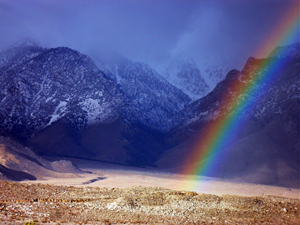 Saline Valley, CA 12-2010
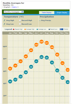 Image 1
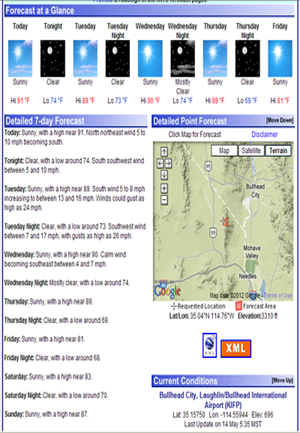 Image 2